
Our research team has recently been working on a project to identify the patterns of subsidence in the UK with soil textures.
Using information from the British Geological Survey, we’ve started to place our own data onto their soil texture maps.
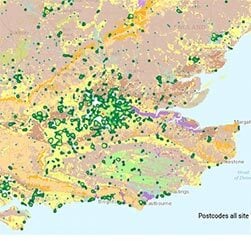
The initial findings highlight the links between various soil types and subsidence. The sample below shows where we’ve overlaid data in a heat map to the BGS UKSO. Clearly, there are strong links between a loam/sand soil texture and subsiding areas, such as the south coast around Bournemouth.
View sample: geobear-ukso
The full white paper with findings will be released later this year. Sign-up below and we’ll email you a copy once its complete.

