
Over the past two months, Geobear has been analysing data to map the hotspots for subsidence in the UK.
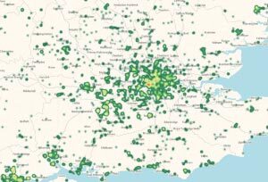
The subsidence maps have been broken down in to regions to provide a more detailed view on reported subsidence. We continue to analyse data and are working with British geological sources to produced a layered version of these maps which will cover soil types.
Geobear, where possible, can provide detailed area maps outlining subsidence hotspots subject to available data. Please contact Aleister Willis for further details.
A list of regional maps is available by clicking here.

